
Property Pre-Purchase Risk Reports to understand the potential risks to your investment and your family.
A peace of mind.
Let us help you protect yourself and your investment by understanding the various hazards threatening your future property and the potential risks they pose to you. In 2026, the average price for a property in NZ is over $900,000. For 0.01% of the price, grant yourself a peace of mind.
Order a Property Pre-Purchase Risk Report today and we'll deliver a full report directly to your inbox within 1-3 business days.
What we provide
Property Pre-Purchase Risk Report
Various factors are often overlooked that could affect property value, cost of future renovations and development, and your physical safety.We look at the property with an engineering lens to provide insights into potentially cost-inducing factors in the future.Imminent climate threats such as earthquakes, landslides, flooding, and sea-level rise affect Kiwi homes across New Zealand every year. We help you answer the question: "How worried should I be?"

Property Pre-Purchase Risk Report
$129.99
Our Standard Property Pre-Purchase Risk Report involves a desktop assessment of the property of interest for risks related to flooding, liquefaction, earthquakes, geological conditions, geographic features, zoning, and basic services (water supply, wastewater, stormwater, power, telecommunications, etc.). We assign an overall risk rating for the property, as well as a detailed breakdown of the risk associated with each category.
Add on: Detailed Flood Risk and Insurance Assessment ($49.99)
Go beyond the basic flood check with a deeper desktop analysis of how water risk could impact your property. This includes flood event likelihood, site drainage, overland flow paths, and potential insurance implications. Let us help you gain clarity on whether flooding could become a costly issue.
Add on: Detailed Ground Stability and Liquefaction Assessment ($49.99)
A deeper desktop assessment of ground conditions and an additional landslide assessment, including soil types, slope stability, groundwater influence, and potential impacts on foundations. Let us give you clearer insight into geotechnical risks and future costs.

Our Risk Framework
At NZ SiteScope we are transparent about how we calculate risk, where our data comes from, and how we are ultimately able to provide you with what you need to better inform your decisions.
Contact us
At NZ SiteScope, we're dedicated to helping you make decisions with confidence. Whether you're looking for more information about our services, have a specific request, or want to explore partnership opportunities, we're here to assist.Fill out our form with your question and we'll respond as soon as possible.

What's Included?
Standard $129.99
Property Pre-Purchase Risk Report
Areas covered:
- Flood and drainage
- Earthquake and liquefaction
- Contaminated land
- Tsunami and coastal inundation
- Site geometry and buildability
- Construction access
- Site constraints
- Planning and zoning
- Existing basic services
Add-on $49.99
Detailed Flood Risk and Insurance Assessment
Detailed add-on includes:
- Modelled flood extents
- Drainage infrastructure
- Flood depth estimates*
- Overland flow path analysis*
- Elevation vs flood level*
- Drainage behaviour*
- Infrastructure context*
- Insurance implications*
*Exclusive to Detailed Flood Risk and Insurance Assessment add-on.
Add-on $49.99
Detailed Ground Stability and Liquefaction Assessment
Detailed add-on includes:
- Liquefaction susceptibility
- Earthquake history
- Site geometry and buildability
- Soil types*
- Groundwater influence*
- Lateral spreading and instability*
- Landslide assessment*
*Exclusive to Detailed Ground Stability and Liquefaction Assessment add-on.
Thank you.
We will provide you with your Property Pre-Purchase Risk Report and any other requested services within 1-3 business days. Please do not hesitate to contact us at [email protected] should you have any additional queries.

Our Risk Framework
At NZ SiteScope, we value transparency.
See below to learn how we calculate the risk to your potential future property.
From the data we gather, the factors we consider, and how it all culminates into a risk grading, we keep no secrets. If you would like more information, please contact us below.

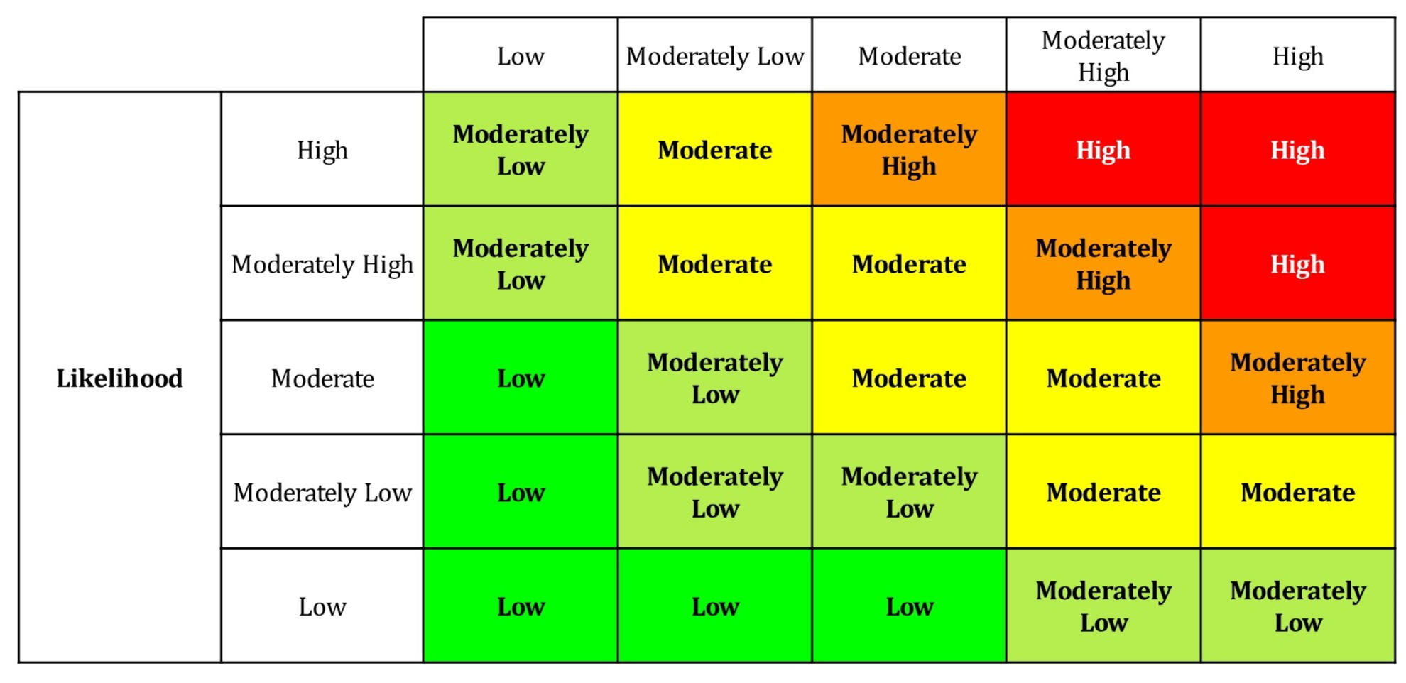
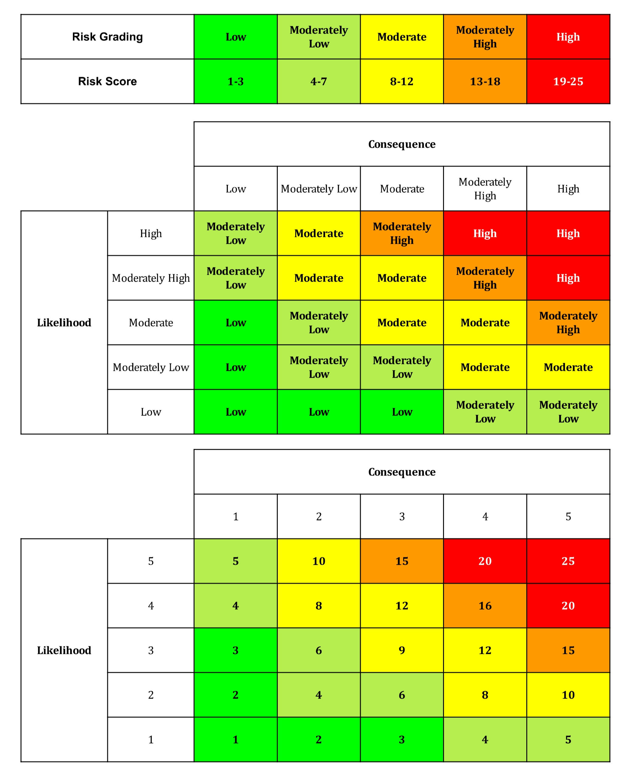
What is Risk?
Risk can broadly be defined to be the effect of uncertainty on objectives, whether that be related to financial goals or physical safety.
At NZ SiteScope, we calculate risk as it is in most engineering, project, and asset management applications:
Likelihood x Consequence = Risk
Flood and Drainage Risk
| Likelihood Grading | Likelihood Description | Consequence Grading | Consequence Description |
|---|---|---|---|
| Low | Not within Flood Management Area Not within Flood Extent | Low | Higher relative elevation Flow path away from property Visible drainage infrastructure |
| Moderately Low | Within Flood Management Area Not within Flood Extent OR Not within Flood Management Area Within Flood Extent 200 Year | Moderately Low | Average relative elevation Flow path away from property Visible drainage infrastructure |
| Moderate | Within Flood Management Area Within Flood Extent 200 Year | Moderate | Average relative elevation No clear flow path away from property Visible drainage infrastructure |
| Moderately High | Within Flood Management Area Within Flood Extent 50 Year | Moderately High | Lower relative elevation No clear flow path away from property Visible drainage infrastructure |
| High | Within Flood Management Area Within Flood Extent 10 Year | High | Lower relative elevation No clear flow path away from property No visible drainage infrastructure |
Note that the above likelihood and consequence criteria are subject to minor adjustments based on the data available for the property being assessed.
Earthquake and Liquefaction Risk
| Likelihood Grading | Likelihood Description | Consequence Grading | Consequence Description |
|---|---|---|---|
| Low | Very low liquefaction vulnerability No liquefaction observed in 2010-2011 earthquakes | Low | Minimal ground deformation expected - rock, dense gravel, very stiff clays |
| Moderately Low | Low liquefaction vulnerability Liquefaction damage is unlikely Minor degrees of liquefaction observed in 2010-2011 earthquakes | Moderately Low | Minor ground effects possible - dense sands, well-compacted fills, stiff silts |
| Moderate | Liquefaction category is undetermined Moderate degrees of liquefaction observed in 2010-2011 earthquakes | Moderate | Noticeable deformation possible - medium-dense sands, silty soils, mixed alluvium |
| Moderately High | Medium liquefaction vulnerability Liquefaction damage is possible Major degrees of liquefaction observed in 2010-2011 earthquakes | Moderately High | Significant ground deformation possible - loose sands, silty sands, young alluvial deposits |
| High | High liquefaction vulnerability Severe to very severe degrees of liquefaction observed in 2010-2011 earthquakes | High | Severe ground failure likely - very loose sands, saturated reclaimed land, estuarine / river margin deposits |
Note that the above likelihood and consequence criteria are subject to minor adjustments based on the data available for the property being assessed.
Contaminated Land Risk
| Likelihood Grading | Likelihood Description | Consequence Grading | Consequence Description |
|---|---|---|---|
| Low | No known hazardous activities; typical residential history | Low | Easily removed light chemicals expected. No restrictions on land use (i.e., industrial today) |
| Moderately Low | Limited potential sources (e.g. light rural/residential use) | Moderately Low | Low-level contamination possible. Minimal remediation if required |
| Moderate | Possible historical activities (e.g. horticulture, workshops) | Moderate | Contamination may require testing and impose minor restrictions. Moderate remediation possible |
| Moderately High | Known potentially contaminating activities (HAIL-listed use) | Moderately High | Investigation and remediation likely. May affect building, resale, lending |
| High | Confirmed contamination or strong evidence of hazardous use | High | Hard to remove heavy metals / hydrocarbons. Significant remediation required. Health risk and development limitations, particularly for residential use |
Note that the above likelihood and consequence criteria are subject to minor adjustments based on the data available for the property being assessed.
Tsunami and Seawater Inundation Risk
| Likelihood Grading | Likelihood Description | Consequence Grading | Consequence Description |
|---|---|---|---|
| Low | No Tsunami Evacuation Zone | Low | Elevated site with minimal exposure to inundation |
| Moderately Low | - | Moderately Low | Edge of inundation zone or slight elevation advantage |
| Moderate | Yellow Tsunami Evacuation Zone | Moderate | Within inundation zone, flat site with moderate exposure |
| Moderately High | Orange Tsunami Evacuation Zone | Moderately High | Low-lying site with potential for significant inundation |
| High | Red Tsunami Evacuation Zone | High | Very low-lying, close to coast, direct exposure to flow |
Note that the above likelihood and consequence criteria are subject to minor adjustments based on the data available for the property being assessed.
Site Geometry and Buildability Constraints
| Likelihood Grading | Likelihood Description | Consequence Grading | Consequence Description |
|---|---|---|---|
| Low | - | Low | - |
| Moderately Low | - | Moderately Low | - |
| Moderate | - | Moderate | - |
| Moderately High | - | Moderately High | - |
| High | - | High | - |
Note that the above likelihood and consequence criteria are subject to minor adjustments based on the data available for the property being assessed.
Construction Access and Site Constraints
| Likelihood Grading | Likelihood Description | Consequence Grading | Consequence Description |
|---|---|---|---|
| Low | Direct wide road frontage | Low | New build. Direct access from house to road < 10 m. |
| Moderately Low | Standard access with minor constraints | Moderately Low | New build. Distance to house from road is <50 m. |
| Moderate | Shared or moderately constrained access | Moderate | Existing house. Distance to house from road is < 50 m. |
| Moderately High | Narrow, steep, or indirect access | Moderately High | Existing house. Distance to house from road is > 50 m. |
| High | No direct access or highly constrained access | High | Existing house. Distance to house from road is > 100 m. |
Note that the above likelihood and consequence criteria are subject to minor adjustments based on the data available for the property being assessed.
Planning and Zoning Constraints
| Likelihood Grading | Likelihood Description | Consequence Grading | Consequence Description |
|---|---|---|---|
| Low | General residential, suburban (standard rules, predictable development) | Low | Unlikely to cause design constraints and require consents |
| Moderately Low | Residential hill (more specific rules, predictable development) | Moderately Low | Potential for design constraints and consents required |
| Moderate | Urban residential, terrace housing and apartment buildings (more rules, higher density) | Moderate | Likely to cause design constraints and require consents |
| Moderately High | CBD, town centre, rural zones (mixed used, more complexity) | Moderately High | Expect limitations, some difficulty to develop and limited flexibility |
| High | Coastal and heritage zones, significant ecological areas | High | Expect strong limitations, difficulty to develop, and high uncertainty |
Note that the above likelihood and consequence criteria are subject to minor adjustments based on the data available for the property being assessed.
Risk Grading Calculations
For each risk category, likelihood and consequence is scored as shown in the tables above.
Then, risk is defined as a function of likelihood and consequence.
Likelihood x Consequence = Risk
For a given property, the category with the highest risk grading is representative of the property's overall risk score. A key assumption we make is that the risk of a property is determined by its greatest risk.
Contact us
At NZ SiteScope, we're dedicated to helping you make decisions with confidence. Whether you're looking for more information about our services, have a specific request, or want to explore partnership opportunities, we're here to assist.Fill out our form with your question and we'll respond as soon as possible.